Have you ever looked at a map, GPS location, or geography question and wondered whether latitude is X or Y? You are not alone. Many students and beginners get confused when they see coordinates written as numbers such as 31.5204, 74.3587.
Understanding the difference between latitude and longitude is important because both help us find exact locations on Earth. However, they represent different directions. Latitude tells us how far north or south a place is from the Equator, while longitude tells us how far east or west it is from the Prime Meridian.
You may also see latitude and longitude in school lessons, Google Maps, GPS devices, online maps, computer programming, and geography applications. In these situations, knowing which coordinate represents X and which represents Y can help you avoid mistakes.
The simple answer is that latitude is Y, and longitude is X when using the common map coordinate system. However, some software and GPS systems display coordinates in a different order, which can create confusion.
In this guide, you’ll learn the meaning, examples, usage, differences, common mistakes, and simple explanations in easy English.
Is Latitude X or Y? – Quick Answer
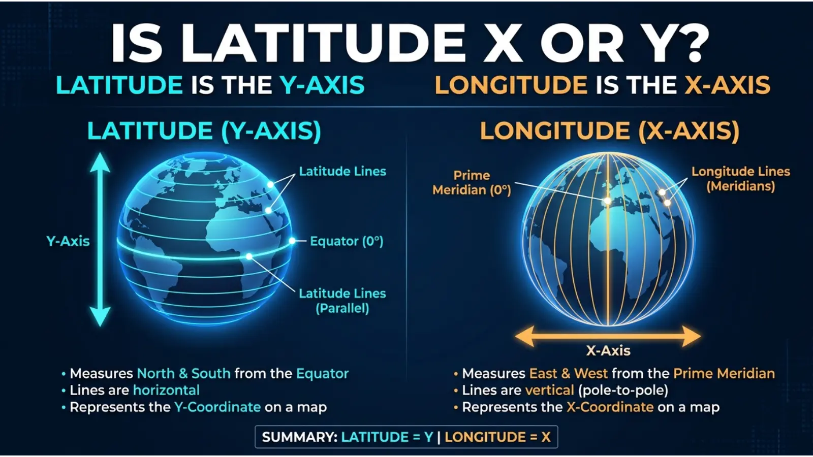
Latitude is Y, while longitude is X in the standard map coordinate system.
Here is a simple explanation:
- Latitude (Y): Measures how far north or south a location is from the Equator.
- Longitude (X): Measures how far east or west a location is from the Prime Meridian.
For example:
- Latitude: 31.5204° N
- Longitude: 74.3587° E
These coordinates represent a location in Lahore, Pakistan.
Examples:
- Latitude is the Y-coordinate on a map.
- Longitude is the X-coordinate on a map.
- A location needs both coordinates to identify its position accurately.
Simple rule:
👉 Latitude = Y = North and South.
👉 Longitude = X = East and West.
Remember that some computer systems list coordinates as latitude first and longitude second. Others use longitude first and latitude second.
The Origin of Latitude and Longitude
Latitude and longitude have been used for centuries to help people understand locations on Earth.
Ancient Greek scholars played an important role in developing geographical coordinate systems. One famous Greek scholar, Eratosthenes, studied Earth’s size and helped develop early geographical knowledge.
Later, mapmakers and sailors improved these systems to make travel and navigation easier.
The word latitude comes from a Latin word meaning width. The word longitude comes from a Latin word meaning length.
These names describe two different directions:
- Latitude lines run from east to west.
- Longitude lines run from north to south.
Today, latitude and longitude are used in GPS devices, smartphones, Google Maps, aircraft navigation, ships, and geographical software.
British English vs American English Usage
There is no difference between British and American English when using latitude and longitude.
Both countries use the same geographical terms, symbols, and coordinate meanings.
| Feature | British English | American English | Notes |
|---|---|---|---|
| Latitude | Latitude | Latitude | Same spelling |
| Longitude | Longitude | Longitude | Same spelling |
| Latitude coordinate | Y | Y | Common map convention |
| Longitude coordinate | X | X | Common map convention |
| North and South | N/S | N/S | Same meaning |
| East and West | E/W | E/W | Same meaning |
For example, a student in the UK and a student in the US will learn that latitude represents the north-south position and longitude represents the east-west position.
Therefore, you can use these terms in the same way worldwide.
Which One Should You Use?
When working with maps, geography, or computer coordinates, you should understand when to use latitude and longitude.
Here are some simple rules:
Use latitude when:
- You want to describe how far north or south a place is.
- You are studying the Equator.
- You are finding a location’s Y-coordinate.
- You are comparing places in the Northern and Southern Hemispheres.
Use longitude when:
- You want to describe how far east or west a place is.
- You are studying the Prime Meridian.
- You are finding a location’s X-coordinate.
- You are comparing locations in the Eastern and Western Hemispheres.
Formal and academic usage:
In geography lessons, scientific work, and professional mapping, use the complete terms latitude and longitude.
In computer programming and mapping applications, you may also see the short forms X and Y.
One important point: Always check the coordinate format required by your software because some systems use latitude-longitude order, while others use longitude-latitude order.

Common Mistakes With Latitude and Longitude
Many beginners confuse latitude and longitude because both use degrees and describe locations.
Here are four common mistakes to avoid.
Mistake 1: Thinking latitude is X
❌ Latitude = X.
✔ Latitude is generally the Y-coordinate in a standard map coordinate system.
Mistake 2: Thinking longitude is Y
❌ Longitude = Y.
✔ Longitude is generally the X-coordinate.
Mistake 3: Confusing the directions
❌ Latitude measures east and west.
✔ Latitude measures north and south. Longitude measures east and west.
Mistake 4: Mixing up coordinate order
❌ Every mapping system must show latitude first.
✔ Some systems use latitude first, while others use longitude first. Always check the required format.
Latitude in Everyday Examples
Latitude and longitude are not only used in geography textbooks. They are also part of many everyday activities.
Here are some practical examples.
1. At Work
People working in mapping, surveying, transportation, and delivery services use coordinates to identify locations.
For example, a delivery company may use latitude and longitude to find a customer’s address.
2. At School
Students learn latitude and longitude in geography classes.
A teacher may ask:
- Is latitude X or Y?
- Which coordinate measures north and south?
- What is the Equator?
The correct answer is that latitude is Y and measures north and south.
3. On Social Media
People sometimes share their location through social media apps.
These apps may use GPS coordinates to show where a photo or post was created.
4. In Daily Life
When you open Google Maps, your phone uses location information to help you find nearby places.
Latitude and longitude work together to identify your position.
5. In Text Messages
Someone might send you coordinates instead of a street address.
For example:
“Here is my location: 31.5204, 74.3587.”
You need to know the coordinate order to understand the exact location.
Is Latitude X or Y? – Google Trends & Usage Data
People search for “is latitude x or y” because they want a quick and clear answer about geographical coordinates.
The confusion is common among students, beginners, programmers, and people working with digital maps.
Here are some reasons why people search for this keyword:
- They are studying geography.
- They are learning about the X and Y axes.
- They are using Google Maps or GPS.
- They are working with location-based software.
- They are learning coordinate systems in mathematics.
- They want to understand latitude and longitude differences.
Popular countries and search interest
People in different countries may search for this question, including:
- United States: Students and mapping beginners may search for coordinate explanations.
- United Kingdom: Geography learners may look for latitude and longitude definitions.
- India: Students may search for simple explanations of geographical coordinates.
- Pakistan: School and college students may search for latitude and longitude questions.
- Canada: Mapping and geography learners may want to understand coordinate systems.
- Australia: Students and GPS users may look for coordinate information.
Search trends
This is an educational, question-based keyword. Its search interest may change with school lessons, exams, and interest in mapping tools.
However, these countries are examples of relevant audiences, not a verified ranking of search popularity. Exact search volume and country rankings require checking Google Trends or a keyword research tool.

Comparison Table: Is Latitude X or Y?
The following table explains the main differences between latitude and longitude.
| Feature | Latitude | Longitude |
|---|---|---|
| Coordinate | Y | X |
| Direction measured | North and South | East and West |
| Starting point | Equator | Prime Meridian |
| Degree range | 0° to 90° | 0° to 180° |
| Line direction | East to West | North to South |
| Line shape | Parallel circles | Meridians |
| Main purpose | Finds north-south position | Finds east-west position |
Example:
Suppose you have these coordinates:
- Latitude: 40° N
- Longitude: 74° W
The latitude tells you the location is north of the Equator. The longitude tells you it is west of the Prime Meridian.
Together, they identify a geographical position.
Latitude and Longitude in Professional Life
Latitude and longitude play an important role in many professional fields.
Here are some examples:
1. GPS and Navigation
GPS systems use geographical coordinates to help people find locations and travel from one place to another.
2. Aviation
Pilots use geographical coordinates as part of navigation and flight planning.
3. Shipping
Ships use coordinates to understand their positions and plan routes across oceans.
4. Geography and Research
Researchers use latitude and longitude to study climate, weather, land, and different regions.
5. Website and App Development
Developers use geographical coordinates to build location-based applications.
For example, a restaurant-finding app may use a person’s location to display nearby restaurants.
In these professional fields, knowing that latitude is Y and longitude is X can help prevent coordinate errors.

Is Latitude X or Y for Students or Beginners?
Students often struggle with latitude and longitude because both terms sound similar.
However, learning a simple rule can make the topic much easier.
Why beginners get confused:
- Both coordinates use degrees.
- Both are used to identify locations.
- Their names are sometimes difficult to remember.
- Different software may display coordinates in different orders.
Easy learning tips:
- Remember that latitude is Y.
- Remember that longitude is X.
- Learn that latitude measures north and south.
- Learn that longitude measures east and west.
- Practice reading coordinates on a world map.
Practice question:
If a map shows a location at 25° N and 60° E, which number represents latitude?
Answer: 25° N represents latitude because it tells you the north-south position.
Signs or Characteristics Related to Latitude
Latitude has several important characteristics that make it easy to identify.
- Measures north and south: Latitude shows the distance north or south of the Equator.
- Uses degrees: Latitude values range from 0° to 90°.
- Runs east to west: Lines of latitude form horizontal circles around Earth.
- Equator is 0°: The Equator divides Earth into Northern and Southern Hemispheres.
- North and south values: Latitude uses N and S to show direction.
- Y-coordinate: Latitude is generally represented by Y on a standard map.
Important lines of latitude:
| Line | Latitude |
|---|---|
| Equator | 0° |
| Tropic of Cancer | 23.5° N |
| Tropic of Capricorn | 23.5° S |
| Arctic Circle | 66.5° N |
| Antarctic Circle | 66.5° S |
| North Pole | 90° N |
| South Pole | 90° S |
These lines help geographers understand Earth’s different regions and climate zones.
Simple Trick to Remember Is Latitude X or Y
The easiest way to remember latitude and longitude is to connect each word with its direction.
👉 Latitude = Y = North and South.
👉 Longitude = X = East and West.
Think of it this way:
Imagine looking at a normal map.
- The horizontal direction represents X.
- The vertical direction represents Y.
- Longitude is X.
- Latitude is Y.
A simple memory trick:
Remember the letter Y in the word latitudY. This can remind you that latitude is the Y-coordinate.
For example, if you see a question asking whether latitude is X or Y, remember:
Latitude is Y, not X.
This small trick can help you answer geography and coordinate-system questions quickly.
FAQs:
1. Is latitude X or Y?
Latitude is Y in the standard map coordinate system. It measures how far north or south a location is from the Equator.
2. Is longitude X or Y?
Longitude is X. It measures how far east or west a location is from the Prime Meridian.
3. Is latitude horizontal or vertical?
Lines of latitude run horizontally from east to west around Earth.
4. Is longitude horizontal or vertical?
Lines of longitude run vertically from the North Pole to the South Pole.
5. Is latitude always written before longitude?
No. Some systems write latitude first, while others write longitude first. Always check the coordinate format.
6. What is the difference between latitude and longitude?
Latitude measures north and south, while longitude measures east and west. Together, they help identify locations on Earth.
7. Does Google Maps use latitude and longitude?
Yes. Google Maps uses latitude and longitude to identify locations, display places, and support navigation.
Conclusion
So, is latitude X or Y? The simple answer is that latitude is Y, and longitude is X in the standard map coordinate system.
Latitude measures how far north or south a place is from the Equator. On the other hand, longitude measures how far east or west a place is from the Prime Meridian.
Both coordinates are important for geography, GPS, Google Maps, navigation, and computer-based mapping.
Remember this simple rule whenever you study geographical coordinates:
- Latitude = Y = North and South.
- Longitude = X = East and West.
Once you understand this difference, reading maps and working with geographical coordinates becomes much easier.

Sara Taylor is a passionate English content writer who specializes in word meanings, spelling comparisons, and modern slang explanations. She creates easy-to-understand articles that help readers avoid common English mistakes and improve their writing skills. Her content focuses on simple learning, real-life examples, and clear explanations for everyday readers.